To understand RTK positioning, this article is enough!


When it comes to positioning, I believe everyone will not feel unfamiliar. We live in an information age where everyone has a mobile phone. Every day, we use apps related to maps and navigation.
These apps are based on positioning technology.
When it comes to positioning technology, everyone will definitely think of terms such as GPS and Beidou. Yes, these belong to the Global Navigation Satellite System, or GNSS (Global Navigation Satellite System).
It is these satellites flying in space that help our mobile phones have positioning capabilities and provide us with navigation services.
Everyone knows the above. Next, Xiaozaojun wants to introduce a concept that may be relatively unfamiliar to you. It is also related to satellites and is one of the most commonly used positioning technologies in the industry, providing great help for our work and life. It is - RTK.
What exactly is RTK? When you have a satellite, why do you need it? What are its features and how does it work?
Don't worry, let Xiaozaojun come one by one.
What is RTK
RTK, the full English name is Real-time kinematic, which is real-time dynamics. This is an abbreviation, and the full name should actually be RTK (Real-time kinematic, real-time dynamic) carrier phase difference technology. (For ease of reading, I will still abbreviate it as RTK in the following.)
Don't panic! Although this technology looks very professional, the actual principle is not complicated.
RTK is a technology that assists GNSS.
Why assist with GNSS? Of course, it is because of the shortcomings of GNSS itself!
As we all know, the reason why GNSS satellites can locate terminals on the earth (such as mobile phones, cars, ships, airplanes, etc.) depends on the three-dimensional coordinate system.
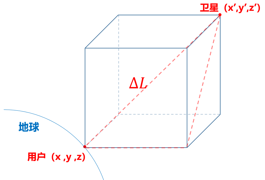
Find at least 4 satellites and calculate the distance ΔL between each satellite and the terminal (this distance is also called "pseudorange"), and you can list 4 equations.
After the calculation, four parameters of the terminal can be obtained, namely longitude, latitude, elevation (altitude) and time.
The speed of the terminal can also be calculated from the position change per unit time. Three-dimensional coordinates, speed, and time information are usually called PVT (Position Velocity and Time).
With satellites alone, we can get PVT. However, note that there are errors in satellite positioning.
Errors come from both inside and outside the system. For example, errors generated when satellite signals penetrate the ionosphere and troposphere, errors caused by the Doppler effect caused by the high-speed movement of satellites, as well as errors caused by multipath effects, channel errors, satellite clock errors, ephemeris errors, and internal noise errors. and many more.
Some of these errors can be completely eliminated, and some cannot be eliminated or only partially eliminated. They affect the accuracy and reliability of the system.
Well, our protagonist is finally coming.
In order to better eliminate errors and improve positioning accuracy, industry experts have developed a more powerful positioning technology, which is RTK.
How RTK works
Let's go straight to how RTK works.

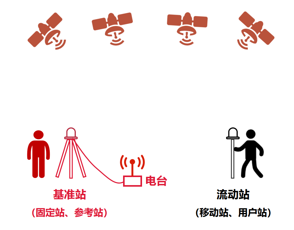
As shown in the figure above, this is a standard traditional RTK networking. (Is it super easy?)
Among them, in addition to satellites, the RTK system includes two important components - the base station and the rover.
Both stations have satellite receivers that can observe and receive satellite data. As the name implies, a base station is a base station that provides a reference datum. A rover, on the other hand, is a station that can move continuously. The rover is actually the object that wants to measure its own three-dimensional coordinates, that is, the user terminal.
We often see people outdoors carrying tripod equipment for measurements. Some of them may be carrying RTK base stations or rover stations.
Let's take a closer look at the positioning process.
First of all, the reference station is used as a measurement reference, and it is usually fixed in an open place with a good view. The three-dimensional coordinate information of the reference station is generally known.

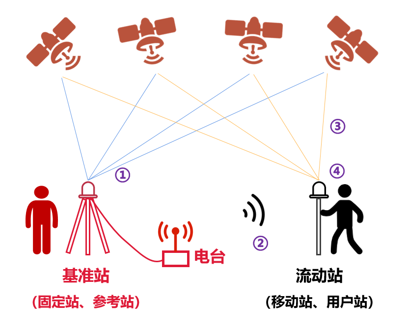
Step ①, the base station first observes and receives satellite data.
In the second step, the base station sends the observation data to the rover in real time through the radio station (data link) next to it (the distance is generally not more than 20 kilometers).
In the third step, the rover also observes and receives satellite data while receiving the base station data.
Step 4: On the basis of the base station data and its own data, the mobile station performs real-time differential operation according to the relative positioning principle, so as to solve the three-dimensional coordinates and accuracy of the mobile station, and its positioning accuracy can reach 1cm~2cm. At this point, the measurement is completed.
As you can see, RTK technology has the advantages of no line of sight between observation stations (no need to be in the line of sight), high positioning accuracy, simple operation, and all-weather operation. It is a very good positioning technology.
Network RTK vs Traditional RTK
What we just said is an early model of RTK, which we call traditional RTK technology.
Traditional RTK technology is simple to implement and low cost. However, it also has a big problem, and that is the distance limit between the rover and the base station.
The farther the distance is, the larger the difference in error factors becomes, and the positioning accuracy will decrease. Moreover, the distance is far, beyond the communication range of the radio station, it will not work.
In order to overcome the defects of traditional RTK technology, network RTK technology was proposed in the mid-1990s.
In the network RTK technology, in a large area, multiple reference stations (3 or more) are evenly distributed to form a network of reference stations.
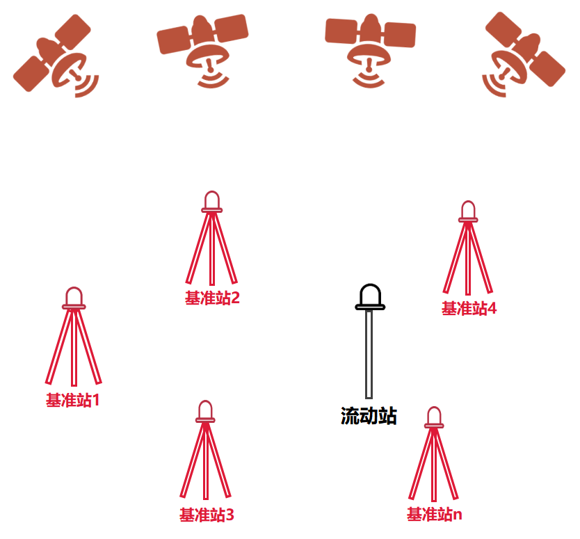
 Base Station Network
So, in this case, does the rover need to compare and measure with each base station?
Of course not, that would be too much trouble.
Compared with traditional RTK, network RTK actually replaces the single-point GNSS error model with a regional GNSS network error model. A network of base stations consisting of multiple base stations that send data to a central server. The central server will simulate a "virtual base station" based on the data. (So, network RTK is also called "virtual base station technology" or "virtual reference station technology".)
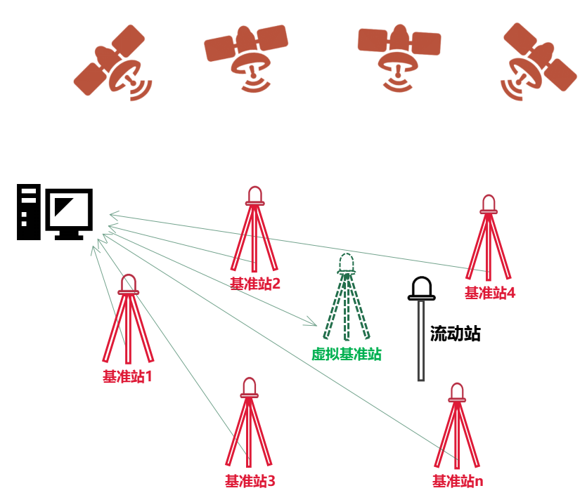
For the rover, it only "sees" this "virtual base". Based on the data sent by this "virtual reference station", the rover completes the final measurement calculation.
The advantages of network RTK are very obvious.
Everyone should have seen that the mobile communication base stations we usually see can actually be part-time "base stations". There are base stations all around us, which means that network RTK basically achieves seamless coverage.
The communication between the rover and the central server can also be accomplished through the built-in wireless communication module of the rover (terminal). These high-precision positioning modules integrate RTK technology and are themselves mobile communication modules, which can achieve the above functions.
Secondly, for users, there is no need to build a base station by themselves, which saves a lot of costs (just need to pay some communication fees).
Third, the accuracy and reliability are higher. After all, there are so many base stations, even if one or two are broken, it will not have much impact.
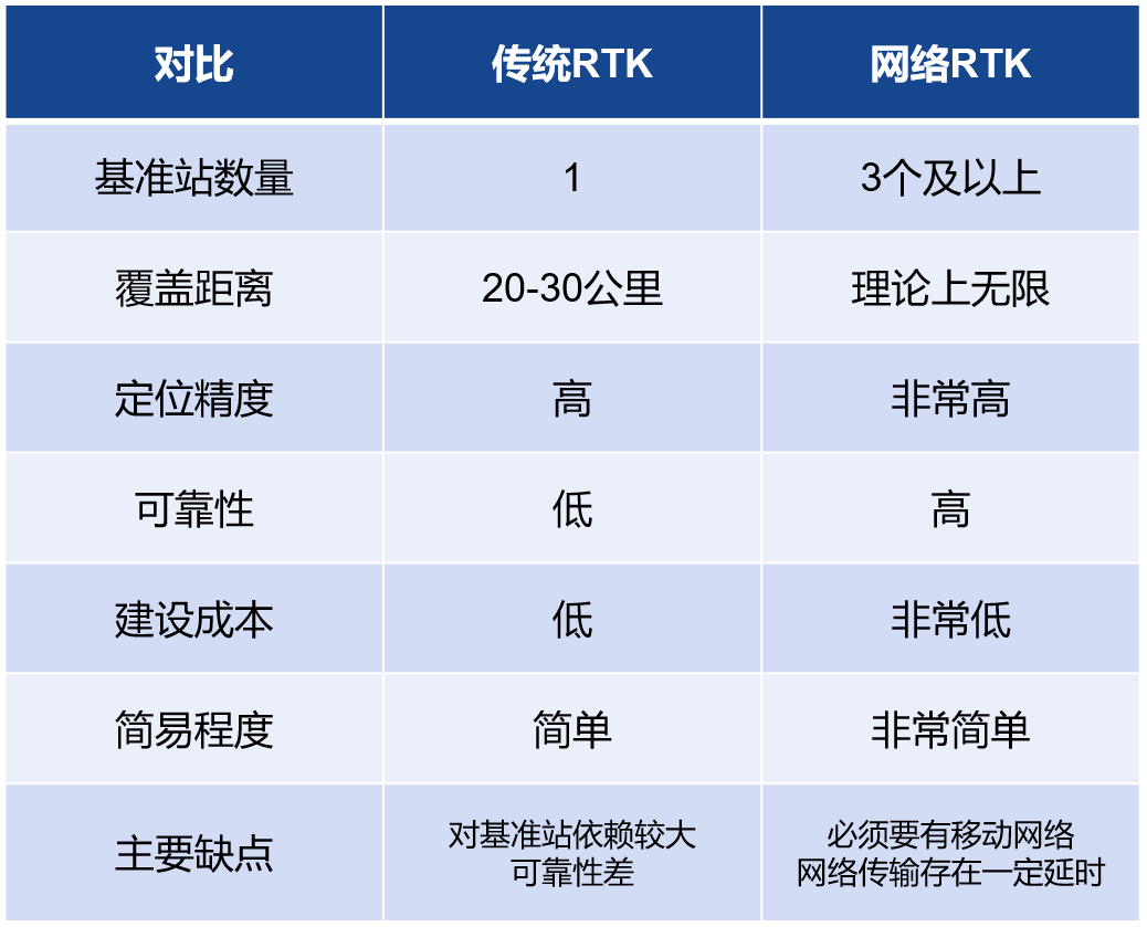
It is worth mentioning that in the network RTK model, the stability of the network has a great influence on the positioning accuracy. It is necessary to ensure the stability of network communication, so as to ensure the stable delivery of differential data, in order to achieve ultra-high positioning accuracy.
Epilogue
RTK technology has become more and more mature after years of accumulation. Its high precision, high speed and high stability make it widely used in surveying and mapping, UAV, vehicle, security and other fields.
In the future, RTK technology will develop in the direction of longer distance, higher precision, multi-frequency and multi-mode, and higher stability. let us wait and see!